Moosburg Online: www.moosburg.org
Stalag VII A: Location

Location Stalag VII A (c. 22 kbytes) 
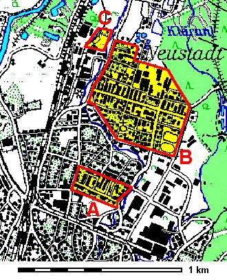
This modern plan of Moosburg's Neustadt (new town) indicates the sites of the former POW camp Stalag VII A:
  1. The guards camp was along Schlesierstraße. Today, some barracks serve as St Pius' kindergarten, the Lutheran parish centre and as residential buildings.

  2. The POW camp (map) itself was further in the north. The main street running from west to east is Sudetenlandstraße where only few original barracks still exist. Private houses, shops and workshops were later built in the area - as well as St Pius' Church and the Stalag memorial fountain.

  3. Stalag VII A had its own railway station (map) connecting the camp to the railway line from Munich to Ratisbon.

Stalag VII A: Map of the camp

Location Stalag VII A and cemetery (c. 61 kbytes) 
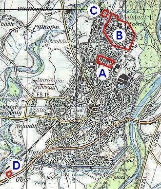
On a smaller scale, the parts of the camp and the whole of Moosburg can be seen:
  1. Guards camp (see above).

  2. POW camp (see above).

  3. Stalag railway station (see above).

  4. The POW cemetery was south of Moosburg at Oberreit (at the federal road B11 to Freising). After the war, the POWs' bodies were transferred to other cemeteries. Today, the site is the Stalag memorial.
Plans: © WebTeam Moosburg
Basic maps: © Bayerisches Landesvermessungsamt

Stalag VII A: Map of the camp

Citizens' Net Moosburg Online Stalag VII A GermanRussian
Last update 10 July 2000 by © WebTeam Moosburg (E-Mail) - All rights reserved!